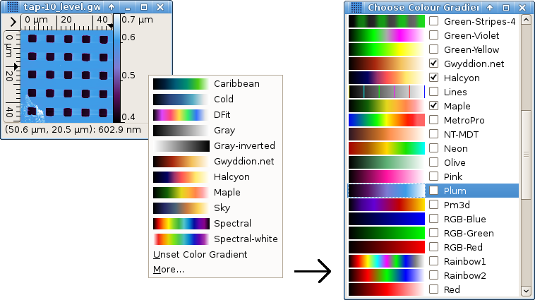
False color mapping is the basic two-dimensional data visualization method. The color gradient (also called palette) to use can be selected after clicking on the false color map part of a data window with right mouse button.
This quick selection pop-up menu offers the list of preferred color gradients. In addition it allows to invoke the full color gradient list by selecting . Preferred gradients can be chosen by checking the corresponding check buttons in the full list or in the gradient editor list. Selecting a row in the full list changes the gradient to the selected one, double-clicking (or pressing Enter) also finishes selection and closes the list window. Gradients of known names can be quickly accessed by starting to type their name. The default color gradient to use (when none is specified in the file) can be also set in the gradient editor.
More control over the way values are mapped to colors is possible with Color range tool.

The Color range tool is a special tool whose purpose is not to analyse or modify data, but to control the way values are mapped to colors. It offers four basic color mapping types:
-
Full

Data values are mapped to colors linearly, the full data range corresponds to the full color range. This is the default type (unless you have changed the default).
-
Fixed

Data values are mapped to colors linearly, a user-specified data range (which can be smaller or greater than the full range) maps onto the full color range. Values outside this range are displayed with the edge colors. The range can be set by several means:
- by entering desired values numerically in the tool window,
- by selecting a range on the height distribution graph in the tool window,
- by selecting an area on the data window, the range is then set from the minimum to maximum of the data in this area only,
- by pressing buttons or that set the range to the range of values that are under or not under the mask, respectively, or
- by pressing button which exchanges the upper and lower limit of the color mapping range.
If no range is manually set, fixed range type behaves identically to full range.
Note data processing operations often modify the value range – and as the fixed range remains fixed as you set it, it can result for instance in completely black data display. You may wish or have to update the range manually then, or to switch to another mapping type.
-
Automatic

Data values are mapped to colors linearly, a heuristically determined subinterval of the full value range maps onto the full color range. Values outside this subrange are again displayed with the edge colors.
-
Adaptive

The full data range corresponds to the full color range, however data values are mapped to colors non-linearly. The mapping function is based on inverse cumulative height distribution, therefore flat areas generally get bigger slice of the color gradient and smaller value variations can be seen on them than normally.
The false color map ruler on the right side of data windows does not display any ticks in this mode, only the minimum and maximum value.
A mapping type can be set to be default by checking the Default check button when it is active. Newly displayed data windows then use this type, unless some other type is explicitly specified.
Saving data to .gwy file also saves all color
mapping settings: mapping type, range and gradient. Gradient is
however not physically stored in the file, only referenced by name. In
other words, color gradients of the same name are shared among files.
Color gradient editor can be invoked with → . It consists of a gradient list similar to the full gradient selector, with an additional button panel, and the actual editor that can be invoked by double-clicking on a gradient you wish to edit or by activating the Edit button. Renaming is possible. Only user-created color gradients can be edited or deleted, system gradients installed with Gwyddion are immutable.
The last button in the gradient list control panel makes the currently selected gradient the default. It will be used for all newly displayed data that do not specify any particular color gradient.
Two editing modes are available:
- Points
The color gradient is defined by a set of points and their associated colors. The points are represented by triangular markers on the gradient displayed in the lower part of the editor window. Moving these markers moves the points, new points can be added by clicking into an empty space, existing points can be removed by dragging them away from the gradient.
- Curve
The color gradient is defined by red, green and blue curves. The curves are again segmented, but the segments of individual curves do not need to coincide.